 The tiling community never fails to impress us, and for this tiling Q&A we go inside the mind of one of the original VeloViewer tilers. Torsten Frank has a rare four digit Strava user number which is indicative of his time on the platform, and he was quick to get on board with VeloViewer, exploring its functionality to maximise his riding experience.
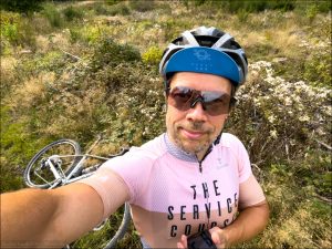
Torsten has a passion for ultra distance racing and regularly blogs his adventures, both on his travels and in his homeland of Germany.
After his Instagram posts caught our attention we got in touch with him to uncover more about his interest in tiling.
VV: How did you discover tiling and what appealed to you about the VeloViewer software?
Torsten: I can’t really say when I discovered VeloViewer but I must belong to the first adopters of Strava in Germany and pretty much also worldwide, as I still have a four digit user number. In 2011 I wrote about the tools and add-ons to track your heatmap. I always loved maps and plotting (both figuratively and literally), routes and following which places I had already visited. Especially which ones by bike and under my own steam. I also quickly adopted VeloViewer when it became available. The whole VeloViewer package gave more insights into my riding and training, including the explorer score, which was just what I wanted, and gave so much more value to my Strava account.
VV: Before tiling what was your motivation to ride, and how has tiling influenced your riding since you started in 2017?
Torsten: Connecting “dots”, i.e. tracing my riding across the map was always a keen interest for me. It’s part of a satisfaction thing by itself, and a nice way to geographically reminisce about past rides. Which might not be so much of interest for all those local training rides at home, but it’s wonderful to see if you have visited some regions to ride, or even better yet, crossed the map to reach said regions. Especially since I do so much bikepacking, I find it super nice to look where I already visited and relive parts of the experience, or even use it to research options for upcoming races or events. “Wasn’t I there in 2020 already? Which route did I take?”. Looking at my VeloViewer Map and clicking on the respective tiles and thus routes is super convenient for this purpose.
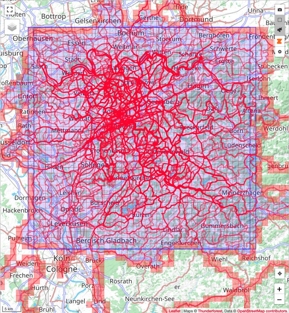
Tiling itself and growing my Max Square is a secondary meta motivation which might be in hiatus sometimes for months but every now and then comes into focus again. Since my Max Square is now quite big at 41 x 41 I don’t reach its edges in normal daily riding. So I really have to make an effort and plan accordingly. Also, since my northern boundary is in the very urban German Ruhrgebiet it only makes sense to ride there on Sundays. Else I become crazy with the traffic and all the traffic lights, but even then time flies fast because there is so many different things to see.
VV: What is your Max Square and Max Cluster, and what challenges have you faced to grow this over the years?
Torsten: My MaxSquare is 41 x 41 and my Max Cluster 2685 tiles. That is now so big, that reaching the edges needs special consideration and might also lead along repetitive roads. Some also not that enticing in a scenic way. That is ok if you explore the region for the first time. But it gets old quick if it’s a rather busy area, and it’s either traffic and traffic lights, or super arrhythmic narrow lanes you basically want to cover quickly to get to the meat of the planned ride, i.e. the new tiles to explore. I much prefer to start tiling from my doorstep but I also did some special tours where I simply drove to a place on the outside of my Max Square and then explored a region.
VV: How do you combat the more difficult to reach squares?
Torsten: When I started I did so mostly with my road bike. Gravel wasn’t really a word back then, but cyclocross was, and of course mountain biking. Also, especially my former home region in the south west corner of Northrhine-Westphalia is the most forested region in Germany. So even with how big a Tile is, there was some bushwhacking necessary occasionally. Thankfully I haven’t come across some real obstacles like big opencast mining areas or airports. If there were, I would see if I could join a visitor group or do some Open Day excursions there and treat it as a hiking activity!
VV:What are your favourite VeloViewer tiling features, and which of the new additions appeal to you most?
Torsten: For sure my favourite is the map itself by far. I value it so much to see all my ridden tracks and the touched tiles in one big view to explore and ponder how to expand it.
For example, I really want to connect the North Sea coast to my ridden and connected area. As such I really like the Max Connected Span new rectangle which surrounds the outer most edges of all interconnected tracks.
The second favourite feature was and still is the Max Square itself, followed by the MaxCluster.
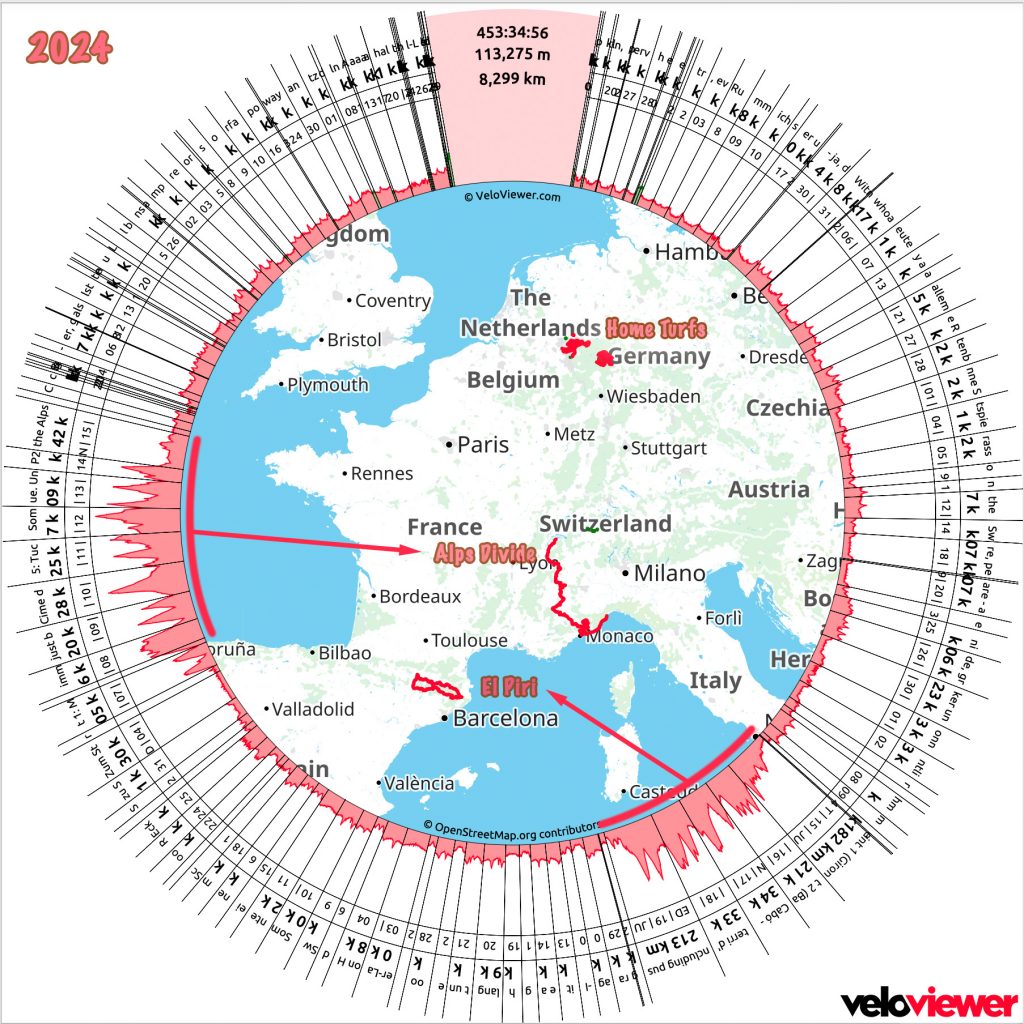
And the third most cherished feature is the VeloViewer wheel. While it’s not a tiling feature in light of my map exploring I really like it and make one for each bikepacking race and event I do and one for every whole calendar year.
VV: Have you set yourself a target for tiles by the end of the year?
Torsten: I refuse to set any target for my riding. I also set 1 km each year as a target when Strava notoriously asks about a target (you can’t enter a zero). So I have that out of my way already with the first ride of the year. And then there is no pressure. Riding will take care of itself and is reason enough in itself. I just need 5 tiles along the southern edge of my Max Square and then it will be 42 x 42. But that’s the situation already for some months and just recently I explored rather a lot of tiles on the northern edge. So I’m happy to prepare quite a bit for quite some time and then – boom – make a big stride with a few corner tiles. In between I enjoy the process, the riding itself and the places I discover.
To find out more about Torsten visit his Instagram.