
A slight lull in work coding for and supporting the professional peloton has allowed me to add some long-outstanding VeloViewer Explorer Tile features, namely the highlighting of newly ticked tiles for an activity in the Activities Map, along with total and new tile count columns.
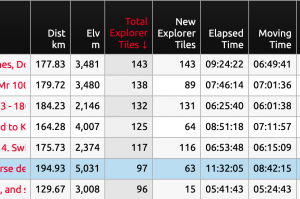
The Summary page has for many years had the ability to plot the number of new explorer tiles for activities on the various charts to show your progress over time, but looking into the details of a specific activity was more of a challenge. The activities page always had the total number of ticked tiles populated for each activity but it wasn’t previously displayed in the table. The code has now been updated to also populate the number of new tiles ticked for each activity. Note that these numbers are based on all synced activities. They aren’t affected by any filters or ordering you may have on the page.
These two new columns are now displayed in the main Activities table and can be filtered, ordered and used in the charts:
As always, clicking a row in the table will zoom/pan the map to display that activity, but now, when hovering the mouse over the row (with the Explorer Tiles enabled) this will highlight the new tiles completed by that activity in Yellow (colour customisable in the map settings popup).
Likewise, if you hover the mouse over an activity line in the map, it will also provide the same highlighting.
This brings the colouring in-line with what you see in the Strava Route Builder when using the VeloViewer Chrome Extension which highlights new tiles in the same colour when plotting routes.
Jim Harley says:
Thanks Ben, I’ve had a bit of a return to square checking of late and this will add to the fun I’m sure. Any chance of the route builder overlay working on Komoot as well as Strava, because I don’t subscribe and even if I did the Strava route builder is pants. Thanks.
Ben Lowe says:
Hi Jim. Unfortunately there are too many route builders out there for me to try and start supporting multiple. The browser extensions are notoriously brittle as virtually any change to the structure/code of their site could stop the extension from working. Supporting the extension on the Strava Route Builder is manageable but I don’t have the capacity to build & support any others.
Mike Sims-Williams says:
This is a lovely update, thanks Ben.
I know this may be beyond your control, but I’m frustrated by Chome having blocked/banned Strava Map Switcher extension, which was really useful for displaying OSM when planning rides in Stravr Route Builder with the VV extension. I can get Map Switcher in Firefox, but not the VV extension. Do you know of any way to get everything in one place?
Ben Lowe says:
I’ll take a look and see how easy/hard it is to convert my Chrome extension to run as a Firefox add-on. I’ll email you when I have any updates.
Nicholas Wild says:
Hi Ben,
This is a really great addition to the explorer tiles and adds (literally) some new dimensions.
I wonder if it would be possible to filter by country for any of the explorer leaderboards.
I’d really like to see a leatherboard relating to the UK specifically for achievements gained on UK soil.
It would allow metrics like percentage of UKs tiles completed – no one will have 100% but I think some have 100% of Netherlands.
And I think the Explorer score would be more meaningful if it was country specific.
Ben Lowe says:
Hi Nicholas. Knowing the country for a person is quite tricky. There is a location provided by the Strava API but it is very inconsistent, sometimes only providing city/region rather than country. And then people move so they might not live near their ma Square/Cluster which further complicates things.
The % of a region ticked was something I looked at a number of years ago and although the code code 90% of the way there, the last 10% kept it from being good enough to release. It also would then open the door to the possibility of lots of support emails saying that this tile should be or should not be included in a particular region which I wouldn’t have time to deal with.
Not ruling it out but I don’t want to provide something that isn’t fit-for-purpose or unsupportable.
Nicholas Wild says:
Thanks for responding and I completely understand. Interesting to hear you looked into it but I can see the issues with borders and peoples localities.
My main focus has been on getting a solid cluster without gaps in it, and the biggest possible big square. In doing this I have been into a lot of obscure and unique squares and was expecting to be high up on the explorer score when it arrived but I see its hard to compete with someone who goes abroad to a remote location and does a long ride. I guess a cluster explorer score would resolve that if it were possible but that may not be the emphasis you were looking for.
I never really considered the max cluster span but I did set myself a LEJOG cluster challenge for 2024 and am now working towards Ardnamurchan point and Lowestoft so your metric really has validated that.
Ben Lowe says:
The way the data is structure doesn’t allow for a “Max Cluster Score” to be calculated but I can see your logic with why that is an interesting angle on things. I might have a look to see if there is a performant way that it can be calculated that doesn’t degrade the speed of things in an obvious way.