Despite taking up cycling at the tender age of 13 (30 years ago!) and doing numerous types of racing over the years, I’ve never actually done anything that resembled structured training in any way. The closest thing I’ve done is go out attacking local Strava hill segments for a summer on the run up to the 2014 Hill Climb season. So, with an Italian Gran Fondo in the diary for early March as a target I thought it was a great opportunity to hook up with a coach and see what gains can be made from a more structured approach. Spoiler alert, it helps, a lot.
Eddington Numbers from your Strava Data
Everyone loves a number to compare themselves with their friends and to gauge your own efforts over time and the Eddington Number is no different. Basically if you’ve ridden 60 miles on 60 occasions, but not 61 miles on 61 occasions, then your Eddington Number would be 60. In order to raise your Eddington Number you’d need to do as many additional rides of 61 miles until you total 61 of them. If this is the first time you’ve heard of the Eddington Number then, like most people, you are currently still scratching your head trying to take that in. But fear not, the Eddington charts on VeloViewer will make it very easy to understand and give you some motivation for some very time-consuming activity!
Continue reading
Strava Club & Friend Yearly Distance/Elevation Leaderboards
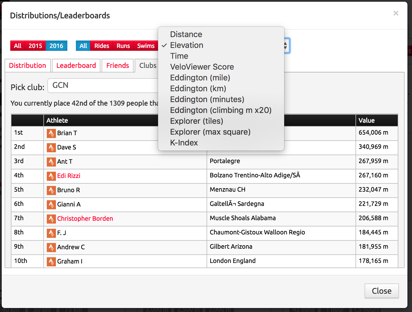 Who in your Strava cycling/running/swimming club has put down the most distance or climbing over the year? VeloViewer’s yearly leaderboards for whole array of different metrics might be just the ticket to finding out. Pick any of your Strava clubs or the list of people you follow to see year or all-time leaderboards for all of the key metrics.
VeloViewer Chrome Extension for Strava Website
 Chrome Extensions allow you to extend any website out there to provide additional features. There are a number of Strava specific extensions already out there with StravistiX being by far the most popular. I’d had numerous requests over the last year for a way to plan routes whilst seeing the explorer tiles so the most obvious way to do this was to use an extension that extended Strava’s Route Editor. And while I was at it I may as well add a bunch of other handy links directly back to VeloViewer as well.
Update (18th Sept 2018): Personal heatmap option added to the Route Builder.
VeloViewer Explorer Tiles and Max Square
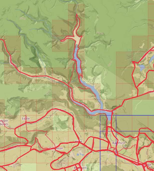 The VeloViewer Explorer Tiles and more specifically the Explorer Max Square has acquired a bit of a cult following since its introduction to the site back in March 2015 despite me not having fully explaining what it is all about until now! The Explorer Score rewards those people who explore new roads/trails rather doing the same old loops. Providing non-performance based motivations has always been one of the main goals of VeloViewer and this one really looks to tick that box.
Projected Year End Distance, Elevation Etc.
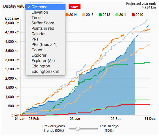 What will be your key stats be looking like by the end of the year? VeloViewer tries it’s best to tell you your projected distance, elevation, time, suffer/explorer score totals and more.
2017 La Course Route/Profile
The women’s race that accompanies the men’s Tour de France has previously been a circuit race around the classic Champs-Élysées loop in Paris. For 2017 the one-day race has moved to the Alps to tackle a section of the men’s 18th stage (the full length of which doubles up as the 2017 Etape du Tour – full details of route here). Here is the full breakdown of the women’s route:
VeloViewer Renewal Information
If you’re reading this then most likely you’ve already been a VeloViewer PRO user so thanks so much for your (hopefully ongoing) support.
Renewal date
At the top of your Update page you’ll see the date that your PRO membership will run until which is 12 months from your previous payment. Your membership will expire at the end of that day at midnight GMT.
Note: The original payment date times are recorded in GMT so your timezone doesn’t make a difference to the length of your membership.
Automatic Renewal
If you set up a recurring payment using the “Subscribe” button then PayPal will take the next payment automatically on the renewal date (at 10:30 GMT by the looks of it) and your use of VeloViewer PRO will be uninterrupted. At least that is the plan! Head to your recurring payments page on PayPal and look for an entry for “VeloViewer Ltd” to check if you have one set up.
Note: I’ve had one user get in touch when PayPal took the recurring payment 5 days late after he had updated thier expired credit card’s details. If you see the payment buttons on your Update page but expect it to have automatically renewed then check out your current payment options in PayPal to make sure they are valid.
Cancelling Automatic Renewal
Should you wish to cancel the automatic renewal then once again, head to your recurring payments page on PayPal, select the entry for “VeloViewer Ltd” and hit the cancel option. You can do this at anytime of your membership and it won’t affect the length of your current PRO membership. When the renewal date passes then you’ll be prompted to renew using the standard PayPal buttons on your Update page.
Non-Automatic Renewals
If you don’t have an automatic renewal set up then you will be prompted to renew when your current membership expires on your Update page. No data will be lost if you don’t renew immediately.
Note: the PayPal buttons will only be shown once you’re current membership has expired and not before so just wait until they are shown.
Switch Between PRO and PRO+
If you want to move from a PRO membership to a PRO+ (or vice versa) then just cancel you current automatic renewal as described above and select the other option when prompted to renew on your Update page.
Bank Transfers
If you previously paid via bank transfer (to the Starling Bank account) then the details are the same as when you last paid but do email me providing your Strava number (the number in your Update page’s URL) when you make the payment so I can check my account and manually sort out the renewal. I don’t get any notification from the bank when a payment is made so I do rely on you notifying me. If the bank details you used for your last payment were for RBS (Royal Bank of Scotland) then please get in touch for the Starling bank account details.
Thanks once again for supporting VeloViewer. Ben
Tour de France 2017 – L’Etape du Tour – Briançon to Izoard – 180km / 3,400m
 L’Etape du Tour is always a classic of an event but for 2017 the parcours is going to provide a really tough challenge. At almost 180km in length the route begins with a fairly relaxed first 120km taking in a scenic tour of Lac de Serre-Ponçon before tackling the Col de Vars and a tough summit finish of the southern slopes of the Col d’Izoard. Expect a few hours of crazy huge pelotons until the climbing properly gets underway!
View the full, interactive route here.

Check out my Fly-Through of the route:
Managing your Strava Starred Segments for Garmin Live Segments
In summer 2015 Garmin introduced Live Strava Segments and since then both Mio and Wahoo Fitness have also introduced the feature to their recent devices (full list of supported devices). Currently the Garmin devices are limited to bringing in just 100 of your starred Strava segments. This resulted in a number of VeloViewer users asking for a quicker way to manage their starred segments when planning trips away as they were going beyond that 100 segment limit. Strava kindly opened up their API for starring segments so I’ve added in the ability to star and unstar segments in every possible location in VeloViewer to make life a bit easier for you.
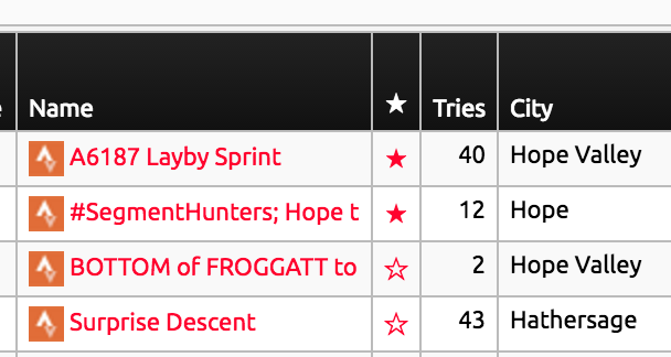 Wherever you see the star next to a segment you can now press it to toggle its starred state. These locations are:
- Segments List
- Efforts List
- Activity Segments
- Route Segments
- Segment Details
I’ve also added a count of your currently starred segments to your Summary page in the header of the “Segment Stats” section which links to your segment list passing the filter to show just the starred segments.