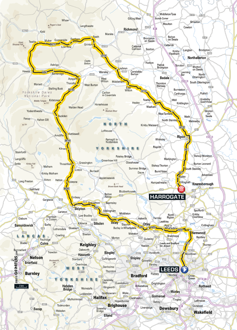
 Stage 1 of the 2014 Tour de France will travel from Leeds Town Hall to the spa town (and home of Yorkshire Tea) of Harrogate in just over 200 km (around 2800 m of climbing) and a sprint finish (and a British Yellow Jersey?) is anticipated. But this stage is by no means flat and if you are planning on riding the stage then you might be interested in knowing what you are letting yourself in for.
Other posts for Tour de France 2014: Climbs of Stage 2, Part 1 – Climbs of Stage 2, Part 2 – Cote de Buttertubs – Cote de Holme Moss – Cote de Jenkin Road – Strines.
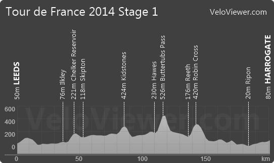
There are mixed reports about how many categorised climbs there will be on stage 1, either just the 1 or maybe 2, but there has been no official announcement that I know of to confirm this. So I’ve pulled together a profile for the stage based on the route map currently provided and it looks like there could even be 3:
Stage Fly Through
Download the kml file for this stage to view for yourself in Google Earth.
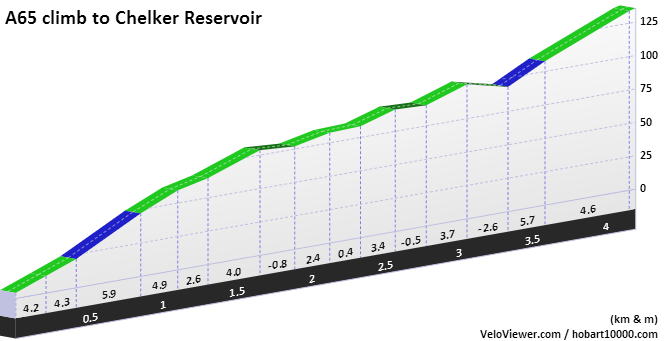
Chelker Reservoir
Elevation gain: 131 m
Maximum elevation: 221 m
Average gradient: 3.1 %
Maximum gradient: 8 %
Strava climb category: 4
View maps, graphs, photos and stats on A65 climb to Chelker Reservoir.
There is a drag out of Leeds up to Harewood but the first time you’ll be needing to get out of the saddle will be the pull up to Chelker Reservoir shortly after passing through Ilkley. Certainly never going to count as a categorised climb in the Tour but probably will act as a good warm up for the climbs ahead. If the 1st break of the Tour hasn’t already stuck then chances are this will offer a good springboard. I remember this climb purely because the wind farm at its summit was the first I ever saw back in 1992, apart from that it is mostly unremarkable.
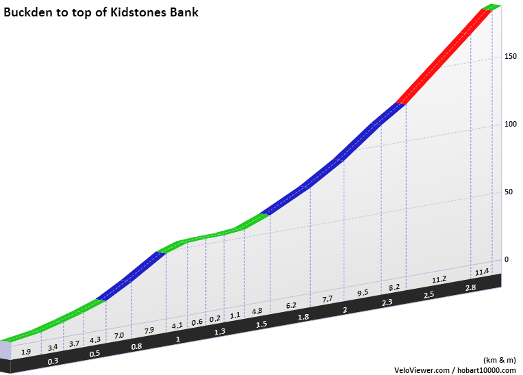
Kidstones
Elevation gain: 185 m
Maximum elevation: 424 m
Average gradient: 6.3 %
Maximum Gradient: 16 %
Strava climb category: 3
View maps, graphs, photos and stats on Buckden to Kidstones.
So if anyone in the peloton thought the opening stage was a straight forward sprinters’ stage then this climb will certainly get a few of the heavier riders drifting back down the line. A mellow start but ever steepening to a fairly painful 16% near the summit. Slightly longer and steeper than Box Hill so should any teams want to start softening up the pure sprinters then this is a good place to begin. If the rumour is true and there are only 2 categorised climbs in this first stage then one of them will be a toss up between this climb and the final climb out of Grinton.
Buttertubs Pass
Elevation gain: 287 m
Maximum elevation: 526 m
Average gradient: 6.5 %
Maximum Gradient: 20 %
Strava climb category: 3
View detailed post on Buttertubs Pass.
View maps, graphs, photos and stats on Buttertubs Pass.
If the Kidstones climb didn’t register on the categorised climb radar then Buttertubs pass certainly will. With a short steep section midway up, this climb will have you hunting through your gears. The summit (at 526m it is the high point of the Tour whilst in the UK, just 2m higher than Holme Moss) is eventually reached after a long, rolling, exposed crossing of the moor which I’ve not included in the profile or stats as it makes it look far less impressive! Read a detailed review about the Buttertubs Climb here.
Robin Cross Hill from Grinton
Elevation gain: 228 m
Maximum elevation: 420 m
Average gradient: 5.2 %
Maximum Gradient: 17 %
Strava climb category: 3
View maps, graphs, photos and stats on Robin Cross Hill from Grinton.
The other possible categorised climb of the stage and a climb I can’t find a proper name for (let me know in the Comments if you know what it is). Steeply leaving Grinton the road briefly levels before kicking up again onto Cogden Moor with the high point at Robin Cross Hill reached after the climb mellows. This is the last chance for any of the teams to drop the sprinters before descending right the way down to the impressive cathedral city of Ripon (although it is the 8th smallest city in the UK with just 16,000 residents) and the very slight rise back up to the finish in Harrogate. If you are riding the stage yourself then on reaching the summit give yourself a good pat on the back but remember to refuel, it’s still 60km to the finish.
The Harrogate Finish
This is my most speculative part of the route especially around the exact placement of the finish line. Stray FM (Harrogate’s local radio station) claim that the finish will be on The Stray which is 200 acres of park that wraps around the town centre. This is an obvious spot due to the great space it affords for the Tour’s village.
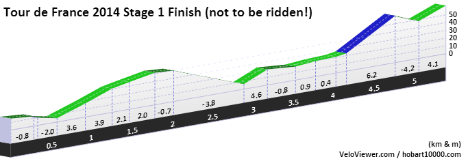
If this is the case and the race is entering Harrogate from Ripon to the north then the profile of last 6km will be something like this:
View graphs/stats/map/photos of the finish in Harrogate.
There will be 2 roundabouts at about 6 km (Ripley) to the finish and a final roundabout at 2 km to go. Apart from that the roads are as good as straight. There is however that 6% ramp with about 1 km to go but at around 600m in length it shouldn’t cause any upsets (fingers crossed… come on Cav!).
Please note: This finish in Harrogate will be going the wrong way up a one-way street. The segment I’ve created in order to display it on my site is just for illustrative purposes. Don’t go riding it!
Here is the route on Strava which allows you to sync the route to your GPS device for those people interested in riding it themselves. It might not be perfect but good enough.
Please let me know in the comments section (or @VeloViewer on Twitter) if you spot any errors. The maximum gradients are a bit of a guess on a few of the climbs but should be there or thereabouts.


Danny says:
Great work… Would love to see a similar post for stage 2.
Ben says:
Already in progress! 13 distinct climbs (in my opinion) on stage 2 so will spread it out over 2 or 3 posts. Friday’s are my TDF2014 blog days!
Martin GT says:
Thanks for this, a great article. Donation your way my man.
livi says:
brilliant..
Darran Moore says:
Climb out of Grinton is Whipperdale Bank, descent is Herontree
LenoirLenoir says:
Great work. Just what I was looking for.
Philip Mcshane says:
wow lot of work went into that
longshot356 says:
Just looked at the route. I live in Harrogate and can tell you the finish is a definite uphill. Sadly it looks much better suited to Sagan than it does to Cav 🙁
Ben says:
I know the pull up past Betty’s but would have thought momentum would get the likes of Cav and Kittel up that. I’ve wondered more about the short climb at around 1km to go. Certainly enough for some of the sprinters to loose their position in the leadout and to let some punchy rider try and make a break for it. Stage 2 has Sagan’s name all over it though!
Akira Seung says:
Guide to seeing the Tour de France in France, finding accommodation… More from
http://www.tdf-tours.com